A Springsure Massacre to a peaceful Lake Nuga Nuga..

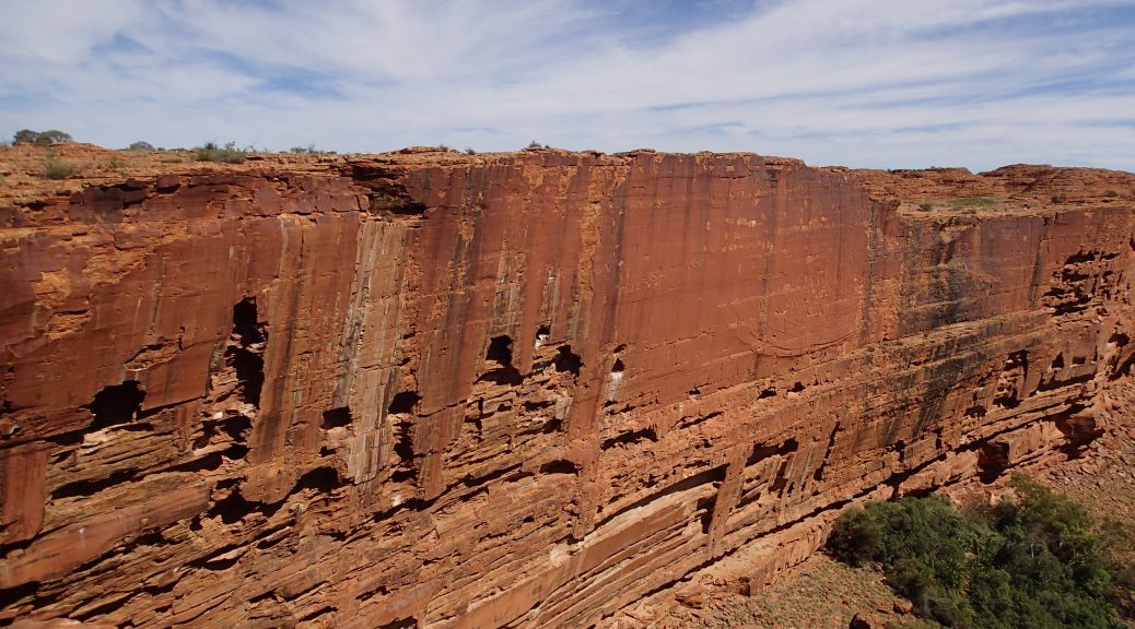
Over the past few days, Nay had been reading about a terrible and gruesome massacre which happened near Springsure in 1861.  As we were very intrigued to find out more about this event, we pulled up just north of town to stay at a rotary park.  From here we had a great view of a sheer mountain cliff and reading further we discovered it was named Virgin Rock.  The rock had been given this title because if one were to look closely, carved by the wind and water over time, is Mary nurturing baby Jesus.

image

Heading west from Springsure approximately 13km we stumbled across a small sign that pointed out “Wills Graves”.  Due to lack of tourist information, we only knew this would lead us to the massacre site from our prior research.  A further 21km down a dirt track, which farmers frowned upon tourists entering as it unsettled their cattle, we made it to the carpark.  With another 1km walk, we finally came face to face with the graves which held a very haunting past. 

The fascinating back story of these murders was that a rich white man (Horatio Wills) had taken a hefty amount of land to run cattle.  Due to another recent killing of many Aboriginals on a nearby station and their dispair of more land being stolen, they decided to take action and retaliate.  Under the cover of darkness they snuck into the Wills camp near the homestead where they murdered 19 members of the Wills party.  This Springsure Massacre was the highest number of white people murdered by Aboriginals in history.  In a total uproar from this deliberate attack, the whites went on a rampage and slaughtered over 250 Aborigines.  To date the numbers are still unknown of how many died but we quickly discovered there is minimal information on this disgusting period in the Australian Frontier Wars.

image

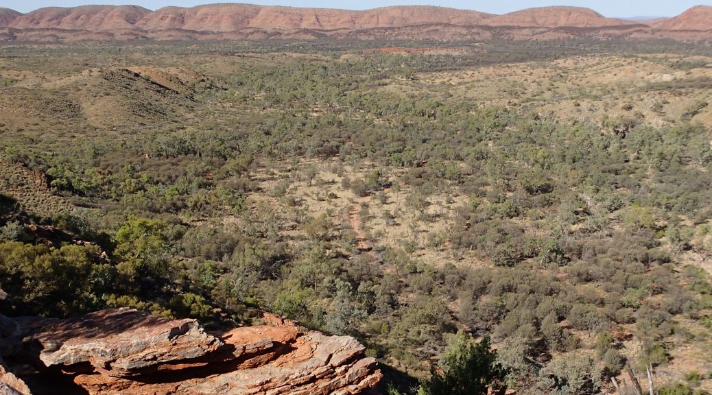
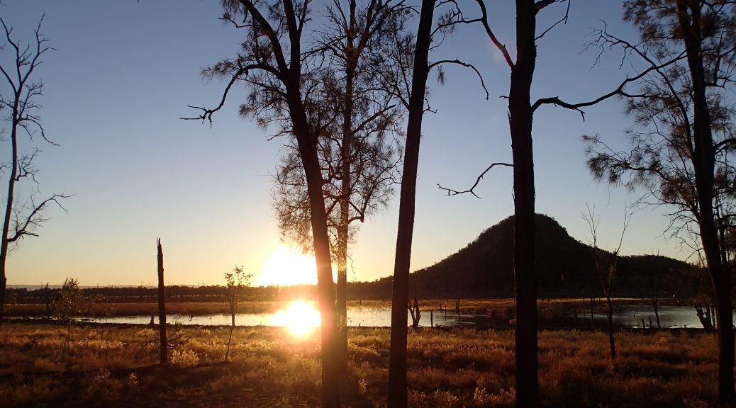
After this history lesson we had lunch in the national park where the Virgin Rock was hidden.  Looking at breath taking views, we found ourselves high up over the town centre and its vast surrounds.  We left the memories of Springsure in the rear vision mirror to make a v-line to Lake Nuga Nuga (we even bumped into farmer George on the way with his 15 dogs in tow!).  As beautiful as Lake Nuga Nuga was, it appeared to be like Lake Eildon during a drought and we wished we could of seen it at full capacity.  It had fantastic surrounds, amazing camp spots with fire pits and many varieties of birds which were calling throughout the day, making it a magical time.  With Mark feeling a little sick we camped here a couple of nights and Nay even spoilt the crew with a mouth watering rum-raisin damper loaf! Delicious!

image

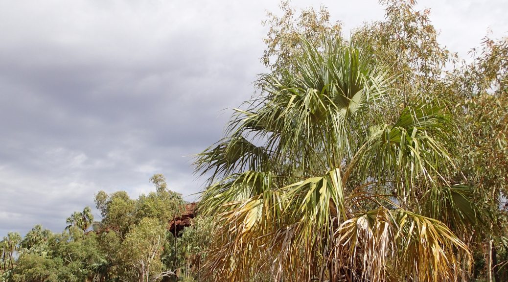
These few days were very restful and did wonders for Marks illness.  Both fighting fit we were ready for the challanging 20km+ walk that Carnarvon Gorge had to offer us the next day…

Disappearing in the depths of a Sapphire..

A rather large drive from Barcaldine and we’d made it into the vast fossicking grounds of sapphires, The Gemfields!  A late arrival lead us to a quick and simple option of camping on a dustbowl of a reserve with some fellow caravans.  As Mark was keen to get a hold of some gems, some researching was done and he found a reasonable looking fossicking tour.  A restless sleep filled with excitement lead to an early 6am rise to see the red skyline as we crawled out of the camper to jump into our mining clothes.  In ragged singlets and shorts, pumped to dig up our fortune, we arrived at the meeting place where we followed our guide Keith to the dig site.  We were quick to discover he was one character of a bloke.

A short demonstration of what to do and we were thrown straight in a hole with a pick and shovel.  We had to dig away the dirt and get down to the old river bed where volcanos, millions of years ago, had erupted shooting various materials (including sapphires).  Here we shovelled the mess into buckets and seived them to a finer rubble.  We then used a smaller seive and put it through a process of washing.  This allowed the heavier material (including the precious sapphire pieces) to move into the centre of the seive.  After flipping it over after a wash we were able to spot if we had any rare and valuable stones in the mix with their glassy edge gleaming at us!

image

After a solid day (with a smoko and lunch break!) and many buckets washed, we were quite successful with a small bag of treats!  Reaping our rewards after getting our hands dirty, we had them inspected by the professional cutter in town.  He informed us that three were of decent quality each worth approximately $100 after cutting!  Rather tired from the days events we retreated back to our reserve where there were only toilets without showers.  Improvising as we do and being so dirty from a days mining, we filled a bucket with water and had a make shift cold shower to the side of the reserve (we’re sure some caravaners were entertained!).

image

The next day lead to some pottering around in the various towns of Sapphire, Rubyvale and Anakie to see what they had to offer.  We ended up stumbling across a grave of a humble piano tuner who was advised not to venture out fossicking due to recent flooding.  Nevertheless, his body was found at a later date.  The good samaritans tried to bury him but since the ground was so swampy, the coffin simply floated!  To finally lay his body to rest, they drilled holes in the coffin so it would sink!  Nearly 100 years after this incident, the “Piano Tuner” still had no name. Finally in 1992 his name was discovered and two plaques (a bit of a mix up there) were made for his restored grave.

image

After this fascinating piece of trivia we left the Piano Tuner to rest and went into Emerald.  After restocking, we took the road sout to soon explore the National Park of Carnarvon…

A prehistoric drive to Barcaldine..

Coasting down the Capricorn Way, windows down, music up, we had not a worry in the world as the town of Winton approached us.  This little piece of outback Queensland is famous for their dinosaur exhibitions as it stands to have found fossils from the age of the great beasts.  As we originally planned to see a museum filled with these great dinosaur bones, this little town offered us other amusements.  We had been informed by the same lovely old mate from the Crocodile Dundee pub, to check out the famous Arno’s Wall in Winton.  Although tourist information didn’t explain this at the site, he gave us the back story behind the wall and how it is famous today.

image

Arno’s Story
There once and still is a gentleman that loves collecting god forsaken rubbish and hoarding it on his property.  Several years ago now there was an exceptionally large and hidious pile alongside council property.  The council had forever harrassed poor Arno to remove this rubbish or they would take action to have it removed as it was an eyesaw.  Now as no tourist information reveals, Arno’s response to the council was to concrete his belongings into a stone wall to stick it to them and forever his hoarding memories remain.  This wall is now a tourist attraction adjacent to Arno’s Park in Winton.

After a bit of messing around at Winton – chatting to a local for a solid hour or so in regards to work, camping at their local billabong and sharing Arno’s memories, we kept heading east to Longreach.  Arriving at Longreach on a Saturday only meant one thing which hadn’t happened for a solid month, a night out!  Staying at a caravan park (with a spa for an afternoon relaxation session), having some afternoon beers with a couple of friendly neighbours, we then found ourselves at the local pub for our first counter meal of the trip!  After a delicious parma and chips, we walked down to another pub to be subjected to some great creative live music and a dj.  Here where we danced the night away and Nay even found herself gaining the attention of an extremely friendly female!

image

You could only imagine the next day was a bit of a struggle.  Leaving after the 10:00am departure time (we had also made good mates with the park managers) we struggled merely 80km east that day to land at Charles Lloyd Jones Weir just south of Barcaldine.  At this tucked away location we rested and spent two nights of free camping chilling by the Weir and they were very protective of their toilet paper in the loos!  We did experience however, our first sight of drizzle since leaving Melbourne.  This didn’t effect us too much as the awning was quickly erected and we took shelter.  Unlike any normal camping adventure we got stuck into a 100 piece jigsaw puzzle!  The rest of the time here flew by and we were back on the road as Mark, like a little kid, was getting very excited about digging up sapphires in the Gemfields!

Historic Road Trip Fact
Barcaldine is home of the Tree of Knowledge and its current housing sadly due to vandalism.  Although deliberately poisoned in 2006, this tree still stands today as a marker for the founding of the Australian Labor Party. 

To Mount Isa and beyond..

The next stretch in our adventure took us to a very small town of Gregory Downs.  Here we camped under a bridge beside a very chilly flowing river and among some grey nomads.  One sadly informed us that we had just missed their annual horse and canoe races!  Slightly disappointed we still had a relaxing evening and went to sleep in tremendously humid weather yet again.  Sleeping very lightly due to the conditions, we were quickly awoken in the middle of the night to a man cackling and using ungodly swearing in regards to aboriginals from an unknown source on top of the bridge.  Minutes later there followed the rumbling of a quad bike, with passengers astride, which we only assumed was searching for the owner of the cackle.  As quick as it all happened, the night was still again, but a slight unease left us feeling Gregory Downs was not the place to hang around.

The next destination was Mount Isa.  A town of two sides – on the east side were mines and the west housed the residents (only a stones throw from the mines!)  This was also the home of School of the Air (a school purely taught over telecommunications and online content).  While we were in Mount Isa we took the opportunity to take a tour of this school for a small $2 and was even able to sit in on a class!  Going through this well presented tour and some of the students backgrounds, we quickly learnt the hardships for kids learning in the outback.  We also took advantage of being in a major town, regathered resources and continued south east along the Capricorn Way.

image

From Mount Isa we tucked into a ghost town of Mary Kathleen.  In saying a ghost town, from the mid 1900’s this establishment was totally abandoned and all that was left were the old cracked foundations of where a buildings once stood.  Not just a few, but dozens and dozens of slabs which left an eerie feeling with us as we drove through the deserted streets.  We of course decided to camp on the hill, right on top of the Catholic church slab!  The next morning lead to exploring an open cut uranium mine nearby.  7km up a dirt track lead to an enormous mine that was filled with water of a vivid sky blue colour (tainted from the uranium deposit).  A little explicit we know, but the picture shows you how good the views were…

image

Back on track we had a pretty cruisy afternoon on the road and found ourselves late in the arvo at a famous pub, The Walkabout Creek Hotel.  This pub was famous for it had starred in Crocodile Dundee.  We were able to stay on a patch of grass in the paddock behind the pub ($10 each!) and even splurged and had a few beers where Dundee had sat with his croc!  As the old boy behind the bar had mentioned of a Combo Waterhole which was the inspiration of Waltzing Matilda, we thought it might be worth a look.  Pulling up to the spot, with a short walk along the creek we came to the actual location where Banjo Patterson sat under a coolibah tree to write his song.  Along the path it also had the intriguing history behind the song.  It spoke of the true tale from when the shearers went on strike and when the swagman was caught and found himself drowning in the river.  After reminicing in this small slice of great Australian history, we were only a few days from finding ourselves in the Gemfelds…

image

The Lawn is Greener on the Hill

A short drive the next morning lead us to an oasis beyond belief.  From an unsealed road with minimal flora or fauna to be seen, we landed in the most beautiful untouched gorge of Boodjamulla National Park (Lawn Hill).  A well deserved swim was had before we sussed the area out to see what adventures this magical place had in store for us.  Already after midday, we had seen that you were able to hire canoes and paddle up the gorge.  Being late in the day we planned this for tomorrow and found ourselves a camp site to rest at for the afternoon.

Tingle the Termite Mound!
Driving along the roads we have come across many a termite mounds.  Talking about it for a while we decided to pull over by one of the larger ones, dress him up, and call him Tingle!!

image

Once again using the trusty Wiki Camps app, we dropped in beside a river about 100m away from some other campers.  After just seeing the Boodjamulla Gorge in all of her beauty, this private little paradise we stumbled across was picture perfect.   Straight from a postcard, was a crisp lagoon with crystal waters and palms all around which gave plenty of shade.  Having a cruise on the surfboards and a peaceful afternoon of nothing, we started up the fire as the sky grew darker and the cane toads emerged for the nights event…

image

As we settled in we saw some torches from a distance emerge over towards our campsite, assuming our neighbours coming for a chat. As three Aboriginals emerged, our neighbours were in fact the Waanyi people, traditional owners of the land in which we were camping. At first we thought we were in trouble, us white fellas trepassing on their land – but they were however, just coming over for a chat. 10 minutes earlier Nay had spotted a snake shoot after a toad at lightning speeds only a mere half a metre away from her chair.  Slightly on edge but thinking this reptilian predator was long gone, came the arrival of our Aboriginal neighbours. 
After informing us that the snake would have only been a harmless tree snake, Nay casually says “There’s it is.” as a brown snake slithers out from some local shrubbery less than 2m away from us!  As the five of us shot backwards one yells “Throw me ya shovel brudda!” and without hesitation starts wailing on the dangerous snake with weapon in hand.  After many a hits the snake went limp and was quickly thrown on the fire.  Adrenaline pumping and repeated phrases of “That’s a brown snake, dem snakes will kill ya!”, there had been some form of twisted fate that had brought them over at the right time, and our snake problem was solved.  You can only imagine after those events that the night was wrapped up quickly and we were tucked away safely in our roof top tent.

image

The next day brought an early rise as we were to walk the gorge before the heat kicked in.  Back to Boodjamulla Gorge we completed the 4km loop that included the lookout which gave breathtaking views.  Once this walk was complete we headed over to hire a canoe.  A robbery of $27/hr with no other canoes 200kms in all directions, we sucked it up and went.  Least to say it was worth every dollar.  A short row up stream and we hit a series of large waterfalls and a swimming hole which was spectacular to explore.  From here we dragged the canoe along a short path and dropped it in the upper gorge.  Continuing to paddle upstream we had lunch along the way on the water (delicious gourmet tuna and saladas) and made it to a couple of smaller waterfalls where no one else had bothered to traverse.  After swimming, snorkelling (seeing an abundance of sealife in the shallows) and just generally enjoying the waterfalls we decided we should be making tracks back down.  With a solid 6km row back to the hire depot, we returned our canoe and jumped in the gorge for one last refreshing swim.

image

For the better of not bumping into another snake companion, we set our sights on Gregory Downs after our massive day of activities at Boodjamulla.

A Fork in the Road..

The next day we arose from our slumber just out from Tennant Creek with a slight buzz, for the morning ahead was to bring a well planned twist in the adventure.  Along the road was a place by the name of Three Ways.  After a discussion a couple of days earlier, instead of back tracking 800 kms south again after Darwin and heading north at Three Ways, we were heading east!!

This last minute unplanned twist added some excitement to the day as we were venturing into greener yet still unknown pastures.  Burning down the Barkley Hwy we had to pull over at the border to have another glamorous photo with the sign!  With the road blurring by at 100kms there was one lucky fellow who wasn’t quite ready to kick the bucket as he missed our wheels by mere centimetres.  A wild and displeased looking blue tongued lizard was hissing on the road when we chucked a u-turn.  Disgruntled as the lizard was, Mark was quick to pick him up and sneak him into the bushes not before a quick photoshoot.

image

Once everyone was safe we were back on track to make it to our destination of Camooweal.  Here we were able to duck off the track beside a billabong where stunning water lillies were flowering and native birds were keeping us entertained around the water.  When the sun had dropped over the mountain range another friend emerged from the dark, the cane toad.  This was not the last we were to see of this plague as it unknowingly had a great impact on an event to happen in the near future.  Rediculous humidity also seemed to give us a slap in the face while entering QLD as you could see from the pic… Mark was sweating serious balls that night!!

image

With a fresh morning we regathered from a rough sleep and set our minds on our next destination, Lawn Hill.  Leaving Camooweal we took a shortcut through unsealed roads where we arrived approx 100km south of Lawn Hill itself beside the O’Shannassy River.  Ducking down another 4WD track after sneaking past a caravan we arrived at our own littlr remote riverside getaway.  We spent some time here to relax and swim while Renee was throwing ideas of homemade scones for afternoon tea!  As the arvo passed Mark was using a creative rock and reel to catch dinner, sadly only caught a small fish not worth cooking.  As the days activities where winding up, Renee had indeed whipped up a scone mix and thrown it in the camp oven.  Before we knew it there were scones with jam and cream for arvo tea!

image

After a change of pace from the billabong we were finding ourselves having another leisurely swim in the river the next morning.  Once refreshed we jumped back on the unsealed track that lead to Lawn Hill..

Alice and Her Desolate Surrounds

At the far eastern end of the MacDonnell Ranges the road lead us straight into the town of Alice Springs.  We spent the opportunity here to regather ourselves, stock up, and catch up on the world around us.  It had been since Coober Pedy (8 days previous) that we’d seen a supermarket!  Staying at the Stuart Caravan Park we were also able to catch up with the folks as phone reception was flourishing!  Well reminded by them that we also landed in Alice on a public holiday and had Anzac day to follow.  Being the good people we are we made our way into town for the Anzac Parade down main street and up to Anzac Hill where we watched the Service.  A great way to start the day and a good excuse to end up at the pub for lunch.

image

These few days of doing very minimal flew by and it wasn’t too long until we were off to our next destination.  There was only one small pocket of national park close to Alice we hadn’t yet explored, Owen Springs.  Only 45 minutes back south down the Stuart Hwy we made it to the turn off.  Name sounds promising, tourist information said there were water holes, the pamphlet even stated “water holes”.  To our demise we found no such signs of water but rather the contrary, we camped in the river bed itself.  Totally remote and only wildlife around us in the outback, even with no water we had ourselves a blast with a fire and homemade cheese/herb damper (getting experimental now!).  Cruising through the rest of the national park was rather disapointing as the brochure also stated points of interest alog the way.  Only 2 of 9 were actually signposted which was the first homestead built in the NT and an old Aboriginal dwelling where they lived when working on the station which included a small tin shed to sleep in, a shower shed and outhouse.

image

Finding ourselves back on the hwy north of Alice we were heading toward Tennant Creek.  We stayed at another couple of overnight camps thanks to Wiki Camps and Nay.  Maybe make that one of two as the first night every road train that passed would wake you up, a train with a solid number of 30 carriages passed and to top it off a mindmill no more than 20m away from the tent made a loud “clunk” as it was blowing gracefully in the wind.  On this stretch of the highway we were also able to explore the Devil’s Marbles (Karlu Karlu).  We would definitely suggest now to travel central Australia north to south.  As impressive as these granite marvels are, the sheer magnitude of Uluru was uncomparable and too fresh in our memories.

image

Making it to Tennant Creek we had another relaxing day by their man made oasis in the desert, Lake Mary Ann.  This was one of the first days we hadn’t planned a walk or any sight seeing, and it felt wonderful to just swim in the water and lay in the sun with a good book..

Along the MacDonnell Ranges

As we drove into the far west end of the MacDonnell Ranges, the scenery before our eyes changed again.  The landscape was filled with a variety of greens and mountain ranges coated in spinifex, had formed on either side of the highway.  Now, we had both learnt a lot about spinifex over the information boards we read, a very interesting plant which thrives in desert conditions and has a root system 10m deep so it could reach a suitable water source.  All kinds of wildlife are dependant on these plants for shelter and protection in their day to day lives.  The first night we dropped in on a riverbed camp spot where we met another two couples.  We enjoyed some delightful beverages in front of the fire and shared stories from the past and future adventures we were to experience.  Lets not lie… it did get a little out of control!
A local spinifex shrub and its MacDonnell Ranges habitat

image

As an overall sum up of the ranges, you would call it a “mixed bag” of adventures.  We spent a good few days in here and each gorge or site had things to do for everyone.  Starting at the far west end we had Redbank Gorge.  We were informed by the info sign to bring an inflatable mattress to enjoy the float down the gorge.  Not knowing what to expect we reluctantly spent 15 mins in stinking hot weather blowing up the lilo.  Then carrying the lilo for further 20 minute walk in, we hoped it was worth it.  Well it was!  We spent a good 45 mins – 1hr floating down the beautiful gorge where some areas were as narrow as 600mm and others as wide as a car.  Light trickled in to bounce off spectacular cuts in the cliff edges which were a variety of colours.  We  also passed many a happy (We all know frogs go “La Di Da Di Da!!”) and well camouflaged frogs along the way.  Starting to get bloody cold we had to turn back with the unknown of how far the gorge would last..

image

As we traveled further east we dropped in on a few sandy gorges with great big waterholes.  Others were just lovely walking tracks to smaller gorges and an abundance of other treks from there.  Each turn off down the main drag was also scattered with history and local knowledge of what the place means to the Aboriginal people.  An example of this were the Ochre Pits.  A short 300m walk to the info board and it had all the knowledge on a substance we never knew existed.  Mined in only a few places around Australia (including the MacDonnell Ranges), Ochre is still used today in many traditional ways including medicinal needs and body paint.  After writing words on rocks and drawing on each other with this chalk like substance, we moved on to the next place of mystery.

image

As we headed towards the far east end getting closer to Alice Springs we came across more luxurious hideaways, deep water holes and little slices of paradise.  You could easily forget you were once driving through a baron desert..

A bumpy trip to Palm Valley

As we departed our camp dingo friends, the road was rough ahead.  Just under 2 hours of driving on an unsealed corrugated mess, we found ourselves at the Aboriginal community of Hermannsburg which was the site of the old Lutheran mission.  This was a rather large culture shock.  We had a tour through the historical grounds from back in the late 1800s.  The purpose of this mission was to intergrate natives into white culture.  This was also the place where the famous aboriginal artist Albert Namatjira grew up and marked his place in history. After the tour, we went to the local supermarket to buy a loaf of bread (which we’d been longing for since Coober Pedy!) and was actually reasonably priced, unlike the diesal at $2.37c/L!!

A blackboard from the school at the mission

image

We continued our trip back down the road onto a “4WD only” track that headed toward Palm Valley.  This path followed a similar suit to the one earlier that day although some sand and dried up river beds made it entertaining.  Making it to the camp site just before the Valley we bunkered down and relaxed by the Finke River and had hot showers!  We had heard mixed stories about the last of the 4×4 path into the Valley itself and weather or not it was only taken by experienced drivers, otherwise we’d have to walk an extra 8km.  So stragically having dinner at the communal kitchen we striked up a convo with some other campers in regards to the matter.  Mixed opinions all round!  “Definitely need to be very experienced!”, “Need high clearance.”, “Nah you’ll be right mate.” and “You’ll have fun! Just go over and down all the boulders!” was the talk of the kitchen.  Our unsettled minds went to bed thinking what the hell..lets give it a crack in the morning..

The next day lead to more fun and adventure!  Waking up we made our way down the unknown track into the Valley.  Low range and a nice slow pace, we navigated through some contraversial landscapes to find ourselves out the other side and into a gorgeous Valley filled with Red Cabbage Palms. These palms grow only in very particular areas around Australia and if all were put together around the country it would fill a small area of 1 square km.  A 5km walk lead us around the top edge of the Valley to gain an oversite of the entire place and its magic.  This then lead back down where we were taken among the palms and along the riverbed.

image

Back at the car we made our way down the track in which we came for a bumby yet exhillirating exit.  As we made our way back on the riverbed track we came to a halt as a member of the grey army had his caravan bogged to the axles in sand.  A learning curb for us, yet a trying time for another couple who had been with him for over an hour before we arrived, we attemped to get him back on the road.  Working with this old timer who didn’t want a bar of anyones advice, what took another hour after four more cars piled up, he managed to get some distance untill he was back on solid ground.  From here we had a clear path ahead to the Macdonnel Ranges..

image

Exploration of a King!

As the adventure continued from Uluru, we once again made it back on the highway up north to our next destination, Kings Canyon. We camped in another excellent bushcamp rest area (starting to realise NT dominate in this market) where once again had unwanted neighbours drop in on us. All set up facing what we thought was the bush, a family decided to roll up late and camp about 5m right in front of us on the side of a track and ruined our privacy. While we were trying to eat our romantic dinner for two, one of the kids decided to shine his torch right in our faces which obviously the parents thought was fine! On a good note, we were able to use our shower tent and had the first battery powered shower for the trip!

The next day brought the exploration of Kings Canyon. In the morning, after ducking into Kathleen Springs for a stroll down the beautiful and historically rich valley to see the old stockade, we made a late arrival at Kings Canyon. Full spirited we began the 6.7km walk (not reccommended at this stage of the day!) up and along the rim of the Canyon. Absolutely spectacular. The walk took us up and along cliffs, down the valley, into the peaceful Garden of Eden (rainforest like waterhole), and back along the opposing side until we were lead back to the carpark. I don’t think we could of finished the last of the trip quick enough. As we were approaching 3:00pm we were buggered, smashing through the kms, guzzling as much water as we could and wiping the sweat off our brows. Even with a difficult conclusion, we conquered it with smiles and could only laugh at the end with recommendations to never start a walk that large, that late in the day.

2016-04-24_22.09.12

Interesting Historic Fact..

The palm in this below picture is somewhere between 350-400 years old!! These Cycads were scientifically proven to be around back in the dinosaur age!

OLYMPUS DIGITAL CAMERA

Once we had a few lolly snakes and recovered, we jumped in the car and made it to the servo before the Mereenie Loop (an unsealed road joining Kings Canyon, Hermannsburg and the MacDonnell Ranges). This is unfortunately a permit road as it is on Aboriginal Country. We decided the $5.50 for the permit was a lot cheaper than a $1000 fine if caught without one!! We ended up camping at Morris Pass Lookout which is situated on the Aboriginal section of the loop. As we arrived we were welcomed by a couple of friendly dingoes which happily wandered around the camp, sussing our kettle out during the night (see paw print on the table) and giving us the occasional howl. Now, the land here was phenomenal, so untouched as we sat with a 1.25L bottle of coke, some Bacardi and Jim Beam. Tough as it sounds we sat on a cliff, drinks in hand, and watched the sun set, with the all mighty Kings Canyon off in the distance..

2016-04-24_22.23.21.jpg